Aerial drones are changing the view of ag industries. New technology can assist farmers and ranchers with tasks that require time, money, and perfect conditions. Utilizing drone technology gives farmers and ranchers another tool to help them work efficiently, increase productivity, and make good management decisions.
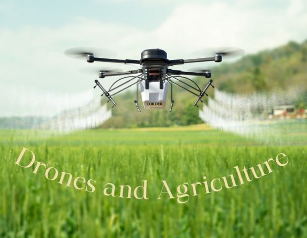
In precision agriculture, drones can assist in several tasks, including soil health monitoring, seed planting, fertilizer application, crop stress management, irrigation schedule planning, weed management, crop yield management, and weather analysis. To spread or spray products on farming land, one model aerial drone, the DJIT40, demonstrates how to achieve these tasks. This model is used for spraying products and spreading cover crops, for example. It is not used for spreading seeds as it cannot introduce seeds to the soil and can only drop them on the surface. Imagine a muddy bog where your sprayer is destined to get stuck or a difficult field to get to in the wetter months. With a drone, the operator sets it and lets it fly. He then just has to keep an eye on it. When a crop stands, a farmer can eliminate driving a sprayer over it and leaving ruts, tracks, and damaging crop stands. This specific drone model can hold 10 gallons of spray and spread. Distribution can be controlled by droplet size, spread pattern, and location. When fully loaded, the drone will weigh about 220-250 pounds.
What is the cost of this innovative and effective solution? A drone bundle costs producers around $34,000 and runs four drones at once, covering 45 acres an hour. In comparison, a new ground sprayer can run you up to $700,000 and cover 200 acres per hour. If a machine like that breaks down, you’re losing money and time. Drones cost less and are fully autonomous, and if one goes haywire, three others continue and pick up the slack.
Perhaps you’re considering a drone for your farm or ranch operation. There are a few other elements to consider before purchasing. Flying a drone requires licensure. Flight requirements include an FAA drone pilot license and an FAA part 137 license. In addition, each state has specific requirements for obtaining local applicator licenses. A person could accomplish getting certified in six to eight weeks.
Drones are helping ag producers in other ways as well. In Kentucky and Colorado, researchers are training drones to find cattle and assess their health from the air. Cattle production is one of the most important agricultural industries in the country, but it has seen challenges due to climate change, lack of labor supply, and land development.
Consider the winter months in Colorado, Wyoming, Montana, and North Dakota. The weather can make finding cattle quite an unpleasant job. In addition, ranchers are busy! To lose one, whether to illness or being lost, costs money. Every year, more than 2.5 million cows in the United States die from health problems. That adds up to a $1.5 billion loss in the cattle industry. Illness in cattle also means they’re prone to eat less and move around less, stunting the growth of calves and impacting their reproduction. What if a drone could patrol pastures to locate cattle, monitor weight, and check for physical ailments such as pink eye? The University of Kentucky is trying to do just that by researching the use of drones and using computer algorithms to build facial identification technology so that drones can identify and track specific cows. Features such as the noses act as cow fingerprints, but if there is dirt or anything else present, the software can be thrown off. A group of unmanned aerial vehicles (UAV) will grab images of cattle from different angles simultaneously for a 3D model. The model will estimate the weight and volume and then keep a record to alert you of any loss or gain. Videos can be taken to monitor activity levels.
Back off PETA, the research team is also studying the effects the hovering drones have on cattle. The team has heart rate monitors and GPS collars to measure the physiological responses of the drones, making sure they aren’t being stressed. If a UAV gets within 8-12 feet, the cows are compelled to move, so the team is studying how to move the cows to round them up. If they are farther away than that, the cows seem unbothered.
This new technology is mind-blowing, and I’m excited to see where it goes. Things can be studied like where and how much cows graze and how that impacts the sustainability of the land. The research is promising, and the vision is inspiring. Ranchers could potentially be able to push a button and have cattle locations and alerts sent to their phones or tablets, making the ranching industry and those who have two jobs a lot easier.