A guide for landowners from Corder and Associates
If you’re buying, selling, or managing property in Montana or the greater Northwest, understanding exactly what you own isn’t just helpful—it’s essential.
At Corder and Associates, we work with many rural and riverfront properties where boundaries aren’t always obvious on the ground. One of the most important tools for clarifying a piece of land is a boundary survey.
Here’s what that actually means—and why it matters.
What Is a Boundary Survey?
A boundary survey is a professional, legal determination of a property’s exact boundaries. It defines where your land begins and ends—not based on assumptions, but on:
- Recorded deeds and legal descriptions
- Historical survey records
- Physical evidence found on the land
- Modern GPS and surveying technology
In short, it replaces guesswork with certainty.
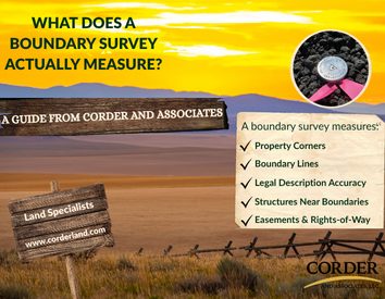
What a Boundary Survey Actually Measures
When a licensed surveyor performs a boundary survey, they’re doing more than just “measuring land.” They’re establishing a complete and accurate picture of your property.
Property Corners
The foundation of any survey is the location of your property corners.
These are typically marked with:
- Iron pins or rebar
- Survey caps
- Stakes for visibility
Across Montana—especially on larger tracts—these markers are often buried, shifted, or missing altogether. A surveyor’s job is to locate or re-establish them using both fieldwork and records.
Boundary Lines
Once the corners are confirmed, the survey defines the exact lines between them.
This is where many surprises happen:
- Fences may not sit on the true boundary
- Neighboring improvements may cross lines
- Long-standing assumptions may be off
In rural areas, it’s common for boundaries to differ from what’s been “used” on the ground for years.
Legal Description Accuracy
Every property has a legal description, which may reference:
- Section, Township, and Range (common in Montana)
- Metes and bounds descriptions
- Subdivision lots
A boundary survey ensures that what’s described on paper matches what exists on the land.
Structures and Improvements
Surveyors also document anything near or along the boundary, such as:
- Homes, cabins, and outbuildings
- Fences and corrals
- Driveways, wells, and septic systems
This helps identify encroachments—when something crosses onto or over a boundary line.
Easements and Access
In Montana and throughout the Northwest, access and utility rights are a big deal.
A survey will identify:
- Access easements (especially for rural or landlocked parcels)
- Utility corridors
- Irrigation or ditch rights
Knowing where these exist can significantly impact how you use your land.
Why Boundary Surveys Matter in Montana
Montana land comes with its own set of realities—and they make surveys even more important.
Big Land, Few Visual Clues
Many properties we represent at Corder and Associates are 20, 80, or hundreds of acres. Out here, there’s often no clear indication where one property ends and another begins.
Natural Features Change
Riverfront and creekside properties—especially along the Missouri River—can shift over time. A survey accounts for those changes according to legal standards.
Fences Can Be Misleading
It’s not uncommon for fences to follow terrain rather than true boundary lines. Just because a fence has been there for years doesn’t mean it marks the legal edge of a property.
Older Records Require Interpretation
Some legal descriptions date back generations. Surveyors often have to reconcile historic records with modern measurements to establish accurate boundaries.
When Should You Consider a Boundary Survey?
At Corder and Associates, we often recommend a boundary survey when:
- Purchasing or selling rural land
- Planning to build a home, shop, or fence
- Dividing or subdividing property
- Clarifying access routes or easements
- Resolving questions or disagreements about boundaries
It’s a relatively small investment compared to the cost of building—or fixing—a mistake in the wrong location.
The Bottom Line
A boundary survey gives you confidence in what you own.
It defines your property with clarity, protects your investment, and helps avoid costly misunderstandings down the road.
In Montana, where land is often wide open and deeply valuable, that clarity matters.
Working with Corder and Associates
At Corder and Associates, we specialize in Montana land—from agricultural ground to riverfront and recreational properties. We help our clients understand not just where a property is, but what it truly includes.
If you’re considering buying or selling land and have questions about surveys, access, or property boundaries, we’re here to help you navigate it with confidence.